|
NOAA CHARTS ONLINE |
| NOAA offers excellent nautical chart resources for both online viewing and downloading. Below you will find quick links to two different product types that are essential references for safe boating in the Thousand Islands Region. | |
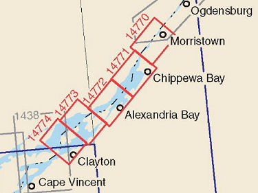
Select a chart by clicking inside the red outlined areas for your region of interest. |
|
NOAA BOOKLETCHARTS™ |
NOAA ONLINE CHART VIEWER
|
 |
 |
| The NOAA BOOKLETCHARTS™ are reduced-size PDF-format pages of charts that you can download and print at home, free of charge. Return by clicking 'back' on your browser. | The NOAA ONLINE CHART VIEWER allows you to view and zoom in on a full-sized image of each of the standard paper charts above. Return by clicking 'back' on your browser. |
We provide these 'quick links' for the convenience of our viewers. Refer to NOAA documentation for terms of use. |
|
| Home |